01 - Map
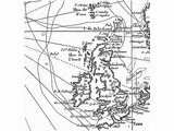
02 - Map of Britain from 1771 by French sailor Kerguelen
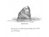
03 - Rockall, sketch in the book "A Vertebrate Fauna of the Outer Hebrides"
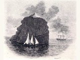
04 - First landing, 8 September 1811, small landing party from the frigate HMS Endymion, led by Royal Navy officer Basil Hall
05 - Aerial view, 1943 (©James Fisher, Wiki)
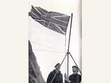
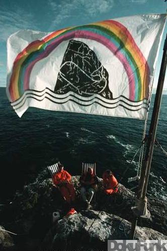
06 - 18 September 1955: Raising the Union Jack (*)
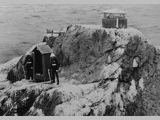
O7 - Security pod with the flag of the Royal Navy and with two marines in full ceremonial dress;the navigational beacon above them (*)
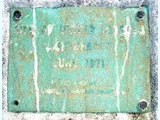
08 - Plaque, at installation of the navigational beacon: "Site of United Kingdom Light Beacon
09 - 13: Northern, Eastern, Southern, Western Front
June 1971" (*)
(*) - Unknown source, any information welcome to ![]() office@dokufunk.org
office@dokufunk.org
Area and History
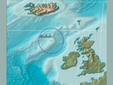
Continent: Europe/North Atlantic Ocean - Coordinates: 57.35.48N 13.41.19W - Zones: WAZ 14, ITU 27 - IOTA: EU-189 (ex EU-164) - Allocations: MS, MM
![]() The origin of the name Rockall is uncertain but it has been suggested that it derives from the Gaelic Sgeir Rocail, meaning skerry (or sea rock) of roaring. There may also be an etymological link with the Old Norse hrukka. - The first literary reference to the island is found in Martin Martin's A Description of the Western isles of Scotland published in 1703:
The origin of the name Rockall is uncertain but it has been suggested that it derives from the Gaelic Sgeir Rocail, meaning skerry (or sea rock) of roaring. There may also be an etymological link with the Old Norse hrukka. - The first literary reference to the island is found in Martin Martin's A Description of the Western isles of Scotland published in 1703:
Geography
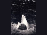
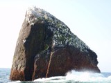
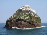
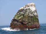
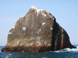
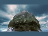
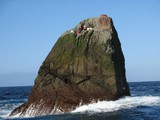
The islet of Rockall makes up the eroded core of an extinct volcano (a volcanic plug), and is one of the few pinnacles of the surrounding Helen's Reef. It is located 301.4 kilometres (187.3 mi), or 162.7 nmi,[8] west of the islands of St Kilda, Scotland, and 430 kilometres (267.2 mi) north-west of County Donegal in Ireland. The surrounding elevated seabed is called the Rockall Bank, lying directly south from an area known as the Rockall Plateau. It is separated from the Western Isles by the Rockall Trough, itself located within the Rockall Basin. (Also known as the "Hatton Rockall Basin".) Rockall lies near the Darwin Mounds, deep-water coral mounds about 185 km (100 nmi or 115 mi) north-west of Cape Wrath. These corals are long-lived and slow-growing; a justification for designating Rockall and the Rockall as a Marine Protected Area. Rockall is regularly washed over by large storm waves, particularly in winter. There is a small ledge of 3.5 by 1.3 metres (11 by 4 ft), known as Hall's Ledge, 4 metres (13 ft) from the summit on the rock's western face. It is the only named geographical location on the rock, other than Rockall as a whole. The nearest inhabited area lies 303.3 kilometres (188.4 mi), or 163.8 nmi,[16] east at Hirta, the largest island in the St. Kilda group, which is populated intermittently at a single military base. The nearest permanently inhabited settlement is 367 kilometres (228 mi), or 198.1 nmi, west of the headland of Aird an Runair, near the crofting township of Hogha Gearraidh on the island of North Uist.
History of landings
The date for the earliest recorded landing was 8 September 1811, when a small landing party from the frigate HMS Endymion, was led to the summit by Royal Navy officer Basil Hall
The next landing was accomplished by a Mr Johns of HMS Porcupine, whilst the ship was on a mission, from June and August 1862, to make a survey of the sea bed prior to the laying of a transatlantic telegraph cable. Johns managed to gain foothold on the island, but failed to reach the summit.
On 18 September 1955 at precisely 10.16 am, in what would be the final territorial expansion of the British Empire, the island was officially annexed by the British Crown when Lieutenant-Commander Desmond Scott RN, Sergeant Brian Peel RM, Corporal AA Fraser RM, and James Fisher (a civilian naturalist and former Royal Marine), were deposited on the island by a Royal Navy helicopter from HMS Vidal (coincidentally named after the man who first charted the island). The team cemented in a brass plaque on Halls Ledge and hoisted the Union Flag to stake the UKs claim.
(Wikipedia)
Media - Interlude
Video: Landing and climbing on Rockall - Amateur footage of a landing on Rockall in June 2005. Kevin "Geo" O'Callaghan leads Larry Hynes up the disputed rock after launching an inflatable - ![]() ext. Link
ext. Link
Video/Audio: The Irish Folkband The Wolfe Tones published, in 1976, their song "Rock on Rockall", supporting the Irish claim of that rock - ![]() ext. Link
ext. Link
Newspaper clipping: "Hello, Mum, I'm on Rockall!"The Guardian, 1 January 2011: A British party hoisting the Union Jack, September 1955 - ![]() ext. Link
ext. Link
The first attempt: RAFARS Project 1965/67
Hitherto unpublished documents!
![]() It all began on 26 January 1965 with a letter written by Squadron Leader A. W. Hannaford, then Secretary of the RAFARS, to Flight Lieutnant John M. Hern, G3NAC, telling him that at a meeting oft he RRAF-ARS Committee held on the 25th January 1965 you were unanimously voted as being the most suitable person in all respects to undertake ex officio duties as Officer in Charge of RAF-ARS D-Xpeditions for 1965. Three days later Hern accepted with pleasure. Just another two days later, on 2 February 1965, Hannaford asked him
to look into the following possibilities for D-Xpeditions
: a. Investigate the possibility of an expedition to Rockall island as an individual RAF-ARS venture in 1965 . b. Report on the feasibility of a D-Xpedition to Rockall next year under the terms of DCI 14/64. c. Submit proposals for any other form of D-Xpedition under the terms of DCI 14/64. (Document DCI 14/64, unfortunately, is not available, but obviously refers to RAF activities to which RAFARS would only contribute.)
It all began on 26 January 1965 with a letter written by Squadron Leader A. W. Hannaford, then Secretary of the RAFARS, to Flight Lieutnant John M. Hern, G3NAC, telling him that at a meeting oft he RRAF-ARS Committee held on the 25th January 1965 you were unanimously voted as being the most suitable person in all respects to undertake ex officio duties as Officer in Charge of RAF-ARS D-Xpeditions for 1965. Three days later Hern accepted with pleasure. Just another two days later, on 2 February 1965, Hannaford asked him
to look into the following possibilities for D-Xpeditions
: a. Investigate the possibility of an expedition to Rockall island as an individual RAF-ARS venture in 1965 . b. Report on the feasibility of a D-Xpedition to Rockall next year under the terms of DCI 14/64. c. Submit proposals for any other form of D-Xpedition under the terms of DCI 14/64. (Document DCI 14/64, unfortunately, is not available, but obviously refers to RAF activities to which RAFARS would only contribute.)
In an undated letter, of probably mid-February, Hern outlines his proposals in a memo, commenting that he does
not consider that DCI(a)14/64 is able to help us in our expedition to Rockall> unless
it was combined with a survey and mapping exercise. In his memo Hern proposes
that Rockall ist the choice with Albania as the alternative. There are natural difficulties with Rockall and political difficulties with Albania.
Rockall cannot be activated by RAFARS alone because the only approach is by helicopter. This will necessitate the use of a sea going boat capable of housing the helicopter.
Hern requests that the President oft he Society writes
to the Admiralty to ask for co-operation and help in putting a helicopter carrying boat
(and)
to the Air Attache in Albania asking for special permission
to go to the Border of Albania and operate there.
The Rockall project was on ist way, although further plans were delayed for a full year. Read on for our summary and/or to consult the complete documentation.
GM4SXU/P - 30 March 1994 - Rockall? Not really
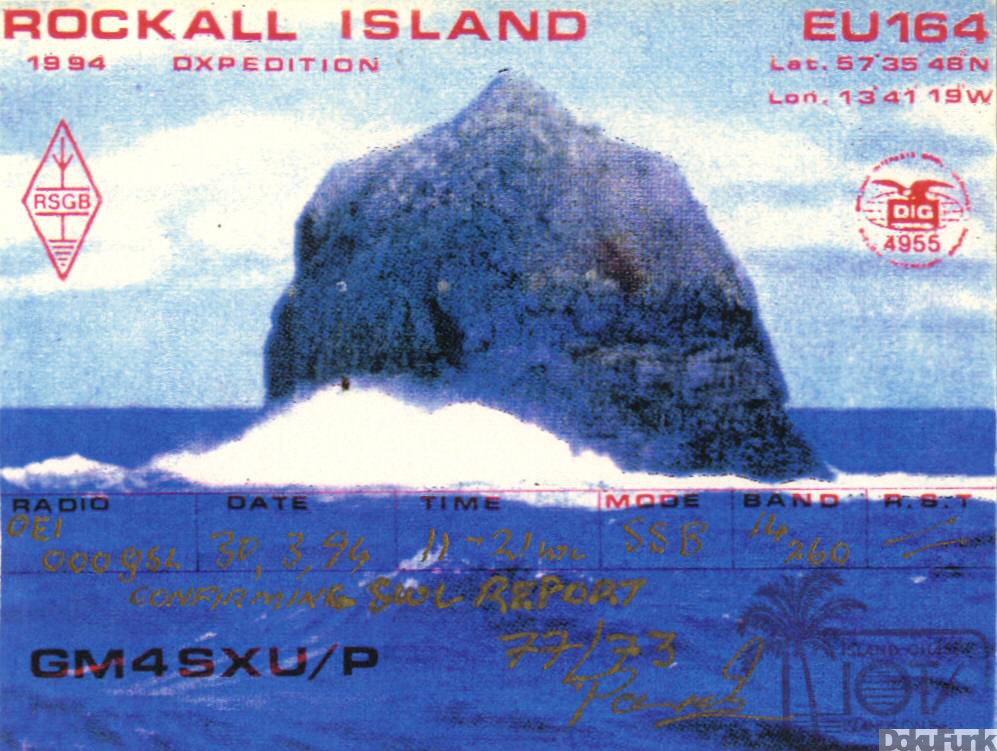
![]() An investigation by the IOTA Committee failed to secure evidence to support the claim that the operation took place from the rock and withdrawal of credit was a natural consequence.
An investigation by the IOTA Committee failed to secure evidence to support the claim that the operation took place from the rock and withdrawal of credit was a natural consequence.
The Greenpeace Waveland intermezzo - 10.-27. July 1997
![]() (Picture © information needed!) A couple of ecological activists from Greenpeace (Al Baker, Meike Huelsman, Peter Morris, Eric Hejsalaar, and Thomas Neuman) occupied Rockall for 48 days. They took turns; mostly, there were three of them on the island. The action was arranged in the view of protesting against the oil research (and pertinent exploitation of the oil) in the surroundings of the island. They lived in a solar-pod, which protected them from the bad weather and declared a new public global state of Waveland. Anyone could apply, via internet for citizenship. Fort he next couple of months hundreds of passports were issued. At the same time the activists declared: By seizing Rockall we claim her seas for the planet and all its peoples. No one has the right to unleash this oil into our threatened climate.
(Picture © information needed!) A couple of ecological activists from Greenpeace (Al Baker, Meike Huelsman, Peter Morris, Eric Hejsalaar, and Thomas Neuman) occupied Rockall for 48 days. They took turns; mostly, there were three of them on the island. The action was arranged in the view of protesting against the oil research (and pertinent exploitation of the oil) in the surroundings of the island. They lived in a solar-pod, which protected them from the bad weather and declared a new public global state of Waveland. Anyone could apply, via internet for citizenship. Fort he next couple of months hundreds of passports were issued. At the same time the activists declared: By seizing Rockall we claim her seas for the planet and all its peoples. No one has the right to unleash this oil into our threatened climate.
MS0IRC/P - 16 June 2005 - The first one

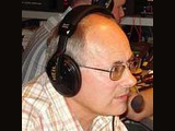
![]() At last, Rockall, 188 miles west of St. Kilda in the Outer Hebrides was no longer the last un-numbered IOTA-island in Europe. On the morning of 16 June 2005, after spending 46 hours at sea a well-equipped and experienced team whose main aim was raising money for charity landed on Rockall. Two of the team were radio hams: MMØALM, David Wood from Stonehaven, and MMØCWJ, Seamus James Cameron, a well-known and experienced island activator, as resident on South Uist possibly the closest ham to Rockall 240 miles out in the Atlantic. Both are members of the Islands Radio Club Outer Hebrides. On arrival the sea was flat calm but the swell was running at about ten feet quite normal in calm weather, yet this made the landing very tricky and it took the team three hours to get everyone, nine people in all, and the radio and safety equipment onto the rock. When the first radio activation from Rockall went on air David kicked off with a CQ call on 40m but very little was heard and only two stations were worked, so he moved to the 17m-band again poor, only eight stations in the log. James took over and went to 20m where conditions were good. The team were constantly downloading weather fax information which showed two low pressure fronts coming togetherin the locality, so due to team safety being top priority the activation had to be cut short from the planned couple of days due to the approaching storm. Thus just nine hours after landing the team had to leave. 3 ½ hours operating, 262 stations worked. Equipment was a Yaeso FT897, 100W; antennas H/B Vertical and dipole; power was from a small generator. The callsign MS0IRC/p is the Hebridean island radio club call. QSL was via G0HXN. The original IOTA number for Rockall, EU-189, was reaciviated due to unauthorised operation from the island.
At last, Rockall, 188 miles west of St. Kilda in the Outer Hebrides was no longer the last un-numbered IOTA-island in Europe. On the morning of 16 June 2005, after spending 46 hours at sea a well-equipped and experienced team whose main aim was raising money for charity landed on Rockall. Two of the team were radio hams: MMØALM, David Wood from Stonehaven, and MMØCWJ, Seamus James Cameron, a well-known and experienced island activator, as resident on South Uist possibly the closest ham to Rockall 240 miles out in the Atlantic. Both are members of the Islands Radio Club Outer Hebrides. On arrival the sea was flat calm but the swell was running at about ten feet quite normal in calm weather, yet this made the landing very tricky and it took the team three hours to get everyone, nine people in all, and the radio and safety equipment onto the rock. When the first radio activation from Rockall went on air David kicked off with a CQ call on 40m but very little was heard and only two stations were worked, so he moved to the 17m-band again poor, only eight stations in the log. James took over and went to 20m where conditions were good. The team were constantly downloading weather fax information which showed two low pressure fronts coming togetherin the locality, so due to team safety being top priority the activation had to be cut short from the planned couple of days due to the approaching storm. Thus just nine hours after landing the team had to leave. 3 ½ hours operating, 262 stations worked. Equipment was a Yaeso FT897, 100W; antennas H/B Vertical and dipole; power was from a small generator. The callsign MS0IRC/p is the Hebridean island radio club call. QSL was via G0HXN. The original IOTA number for Rockall, EU-189, was reaciviated due to unauthorised operation from the island.
(Based on words from Andri, GM3VLB, and ![]() ext. Link )
ext. Link )
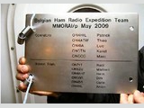
MM0RAI/P - May/June 2009 - A failed attempt

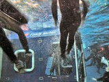
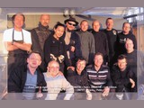
![]() A group of Belgian amateurs had the big idea to activate EU-189 and to become the first group to stay more than 24 hours on the "Rock". The gtwo pioneers beghind the project were Patrick, ON4HIL, and Theo ON4ATW. During the IOTA contest on the last weekend of July 2008 when they were on EU-146 (Goeree island), the idea came to activate a "difficult" island next year Theo is an enthusiastic IOTA chaser, and when he said that "Rockall" was on top of the list, from that time on, the two had nothing else on their mind. Soon two other candidates came to the scene. ON4IA, Luc and Henk, ON4AHF. The first meeting was planned for the 27 August 2008. In that same week Marc, ON6CC joined the team. The first item was how to get to the "Rock" and how much would it cost. First of all they had to be sure they had a boat to bring them from Scotland to Rockall. This would be a two days sail. They had to buy diving suits and climbing gear to climb the 20 meters to the top of the 1,5 by 2,5 meter platform. The idea was to take 2 stations with them... This is how it all began, and almost succeeded. It must have been frustrating to decide, so closae to the rock, to abandon the mission due to extremely bad weather, and to return to Scotland. But they woved to return...
A group of Belgian amateurs had the big idea to activate EU-189 and to become the first group to stay more than 24 hours on the "Rock". The gtwo pioneers beghind the project were Patrick, ON4HIL, and Theo ON4ATW. During the IOTA contest on the last weekend of July 2008 when they were on EU-146 (Goeree island), the idea came to activate a "difficult" island next year Theo is an enthusiastic IOTA chaser, and when he said that "Rockall" was on top of the list, from that time on, the two had nothing else on their mind. Soon two other candidates came to the scene. ON4IA, Luc and Henk, ON4AHF. The first meeting was planned for the 27 August 2008. In that same week Marc, ON6CC joined the team. The first item was how to get to the "Rock" and how much would it cost. First of all they had to be sure they had a boat to bring them from Scotland to Rockall. This would be a two days sail. They had to buy diving suits and climbing gear to climb the 20 meters to the top of the 1,5 by 2,5 meter platform. The idea was to take 2 stations with them... This is how it all began, and almost succeeded. It must have been frustrating to decide, so closae to the rock, to abandon the mission due to extremely bad weather, and to return to Scotland. But they woved to return...
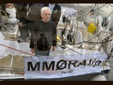
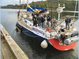
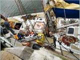
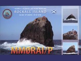
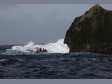
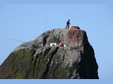
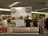
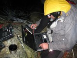
MM0RAI/P - 1/2 October 2011 - Success!
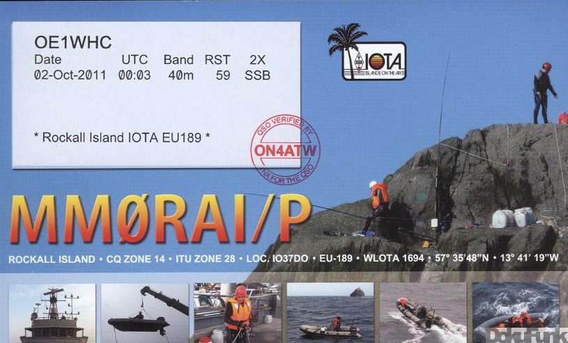
![]() Trying again, the Belgian team succeeded: Saturday, 01 October 11:48 - Patrick, ON4HIL is the first to land on Rockall - Rudi, ON7YT is now also on top of Rockall and they are now moving equipment from the cdt Fourcault to the rock - Equipment now on top. MM0RAI/P EU189 now active, opr. ON4HIL. Operation started on the 1st October at 1545 UTC - Patrick & Rudi are going to stay on the rock until tomorrow around noon, if weather permits. - Stopped transmitting on the October, 2 at 06h52 UTC. 1.200 contacts, almost entirely on 40m SSB.
Trying again, the Belgian team succeeded: Saturday, 01 October 11:48 - Patrick, ON4HIL is the first to land on Rockall - Rudi, ON7YT is now also on top of Rockall and they are now moving equipment from the cdt Fourcault to the rock - Equipment now on top. MM0RAI/P EU189 now active, opr. ON4HIL. Operation started on the 1st October at 1545 UTC - Patrick & Rudi are going to stay on the rock until tomorrow around noon, if weather permits. - Stopped transmitting on the October, 2 at 06h52 UTC. 1.200 contacts, almost entirely on 40m SSB.
Expedition homepage: ![]() ext. Link
ext. Link


Video ON6ZU DVD-Promotion
MS0INT - 2012 - Planned, postponed, and abandoned
![]()
![]() MM0NDX reports a lot has been happening on the planned 2012 Rockall Expedition, MS0INT, but it has now been postponed, due to the MM0RAI/P Belgian Rockall operation. The MS0INT operation has been put off at least a year. "An activation so soon after the Belgian effort now makes Rockall a less attractive target - that is the crux of our decision." But, the organizers say, "It is not lost on us that the majority of the world - still require EU-189 for their IOTA scores." Thus the postponement rather than a cancellation. Donations are being refunded with thanks to operators and groups who had pledged support. (Quoted from Daily DX, #191, 10.10.2011)
MM0NDX reports a lot has been happening on the planned 2012 Rockall Expedition, MS0INT, but it has now been postponed, due to the MM0RAI/P Belgian Rockall operation. The MS0INT operation has been put off at least a year. "An activation so soon after the Belgian effort now makes Rockall a less attractive target - that is the crux of our decision." But, the organizers say, "It is not lost on us that the majority of the world - still require EU-189 for their IOTA scores." Thus the postponement rather than a cancellation. Donations are being refunded with thanks to operators and groups who had pledged support. (Quoted from Daily DX, #191, 10.10.2011)
The project was finally abbandoned. Team website: ![]() ext. Link
ext. Link