Amateur Radio from Desecheo
Area and History
Continent: North America - Coordinates: 18N 68W, FK56 - Zones: WAZ 8, ITU 11 - IOTA: NA-095 - Allocations: K/N/WP5
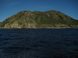
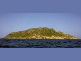
![]() Landing is possible on several places during calm sea, like in Puerto Canoitas on the south side, or Puerto Manolillo, a wide open bay on the west side. The best landing place is Puerto de Lobo Botes, a deep bay on the south-western side of the island. In the vicinity to that bay several houses are located on a table-land, 400 ft above the sea. A ruined and abandoned lighthouse stands near Punta Culebron, 400 meters east of this bay.
Landing is possible on several places during calm sea, like in Puerto Canoitas on the south side, or Puerto Manolillo, a wide open bay on the west side. The best landing place is Puerto de Lobo Botes, a deep bay on the south-western side of the island. In the vicinity to that bay several houses are located on a table-land, 400 ft above the sea. A ruined and abandoned lighthouse stands near Punta Culebron, 400 meters east of this bay.
History
No evidence of Pre-Columbian human settlement of the island has been uncovered, although the Taino natives were dominant throughout the Caribbean until the development of the region by Europeans. The first European to enter the Caribbean was Christopher Columbus, who landed in the Bahamas in 1492 during his second voyage to the New World. Desecheo appears on a map prepared by Columbus' cartographer in 1500, however it was not named until 1517 by Spanish explorer Nuñez Alvarez de Aragón. During the 18th century the island was used by smugglers, pirates and bandits to hunt imported feral goats. In the early 19th century, bird droppings, or "guano," came to be prized as an agricultural fertilizer. In 1855, the U.S. learned of rich guano deposits on islands in the Pacific Ocean. Congress passed the Guano Islands Act of 1856 to take advantage of these deposits. The act specifically allowed the islands to be considered a possession of the U.S., but it also provided that the U.S. was not obliged to retain possession after the guano supply was exhausted. Prior to the adoption of The Guano Islands Act, any territory acquired by the U.S. was considered to have become an integral part of the country's territory unless changed by treaty. More than 50 islands were eventually claimed by the U.S. under this insular scheme, including Desecheo and Navassa. In addition to Navassa, those remaining under U.S. control are Baker Island (KH1), Howland Island (KH1), Jarvis Island (KH5), Kingman Reef (KH5K), Johnston Atoll (KH3), and Midway Atoll (KH4). The U.S. Department of the Interior managed Desecheo and Navassa for many years. During World War II, and until 1952, the island was used as a bombing range by the United States Armed Forces. From 1952 to 1964 the United States Air Force used Desecheo for survival training. In 1976 the U.S. Department of the Interior transferred the administration of the island to the U.S. Fish and Wildlife Service, and in 1983 it was designated as a National Wildlife Refuge.